GanosBase Sfmesh is a spatial-temporal extension of PolarDB for PostgreSQL that lets you store, query, and analyze 3D surface data using standard SQL. Like any spatial database extension, it is built on three pillars: data types for representing 3D geometry, materials, and textures; a spatial index for fast 3D queries without full table scans; and functions for creating, editing, and analyzing mesh objects.
Use cases
Surface mesh models are useful wherever you need to work with 3D geometry in a database:
3D maps and data visualization — Represent physical objects such as buildings, pipelines, and cables as 3D models. Apply materials and textures to simulate real-world appearances for display and decision-making.
3D spatial queries — Filter spatial data based on relationships such as intersection and containment. Useful in spatial data mining, urban planning, and detecting design clashes between datasets.
3D spatial analysis — Calculate area, length, distance, and operations such as intersection and union. Typical tasks include measuring floor area and building volume.
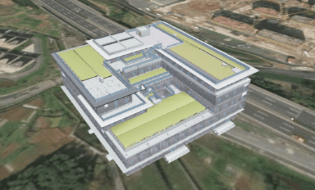
Example: Building Information Modeling
Building Information Modeling (BIM) produces large volumes of 3D spatial data and property data that are well suited to central storage and querying in a database.
The GanosBase Utility extension imports IFC files from BIM programs and converts them to surface mesh models. Once stored, the data supports:
3D visualization — A 3D model conveys spatial relationships more intuitively than a 2D drawing, which is especially valuable for large BIM files.
Attribute queries — BIM data stored in a structured format can be queried with standard SQL alongside other 2D and 3D datasets. For example, to retrieve all components of the "System Panel" type:
SELECT project_uuid, project_name, parent_uuid, uuid, "family", "name", attrs, props_set
FROM ifc_demo_ifc_elem
WHERE
(((props_set->'Other')::json)->'Type')::text like '%System Panel: %'
Spatial analysis — BIM data accurately reflects physical dimensions, so you can calculate floor area ratios, verify net floor-to-floor heights, and detect design clashes with objects from other datasets.

Key concepts
What is a surface mesh model
In solid modeling and computer-aided design, a solid object is represented as a set of connected surface elements that define the boundary between its interior and exterior spaces.

These surfaces are composed of triangles, quadrangles, or other polygons. Together, they form a surface mesh model that accurately depicts the shape of a solid object.
Data models
GanosBase Sfmesh extends OGC's Simple Features with three data models for representing polyhedra:
IndexSurface
IndexSurface describes a polyhedron using a vertex array and a separate index array. For example, the polyhedron below is represented by vertices (p1, p2, p3, p4, p5) and index-defined faces such as (p1, p2, p3), (p2, p3, p4), and (p4, p5, p3).

TriangleStrip
TriangleStrip describes a polyhedron as a strip of contiguous triangles. The polyhedron below is represented by the vertex sequence (p1, p2, p3, p4, p5), forming triangular faces (p1, p2, p3), (p2, p3, p4), and (p3, p4, p5).

TriangleFan
TriangleFan describes a polyhedron by connecting contiguous points to a common center point. The polyhedron below is represented by the vertex sequence (p3, p1, p2, p4, p5), forming triangular faces (p3, p1, p2), (p3, p2, p4), and (p3, p4, p5).

Data types
The sfmesh data type is a composite type that bundles geometry, materials, textures, and texture coordinates into a single object. The following types make up an sfmesh object:
| Type | Description |
|---|---|
sfmesh | The top-level collection. Contains geometry, materials, textures, and texture coordinates. |
meshgeom | The geometric object. Records coordinates, shape description, texture coordinates, and normal vectors. |
texture | Texture mapping information, including width, height, compression method, and binary texture data. |
material | The collection of visual attributes on the object's surface: color, texture, smoothness, transparency, reflectivity, refractive index, and luminosity. |
GanosBase Sfmesh also supports a reference type — a special type that does not contain data but points to another data object.
Spatial reference system
The spatial reference system (SRS) defines how to associate an sfmesh object with a specific location on Earth. GanosBase uses an SRID to link an sfmesh object to its SRS definition.
For more information, see Spatial reference.
Interchange formats
sfmesh objects can be expressed in two text/binary formats:
Spatial index
GanosBase provides a Generalized Search Tree (GiST)-based three-dimensional spatial index for sfmesh columns. It organizes spatial data in a search tree, enabling fast traversal and retrieval without a full table scan.
Create a spatial index on an sfmesh column:
CREATE INDEX <index_name>
ON <table_name>
USING GIST(<column_name>);
Metadata view
The sfmesh_columns view lists all sfmesh-typed columns in the current database. It follows OGC's Simple Features Specification for SQL with additional extensions, and derives its information from the database system catalog.
| Column | Type | Description |
|---|---|---|
g_table_catalog | varchar(256) | The name of the database. |
g_table_schema | name | The schema the table belongs to. |
g_table_name | name | The name of the table. |
g_sfmesh_column | name | The name of the sfmesh column. |
g_sfmesh_type | name | The sfmesh subtype. Valid values: sfmesh, meshgeom, texture, material. |
Query all sfmesh columns in the current database:
SELECT * FROM sfmesh_columns;Filter by a specific subtype:
SELECT * FROM sfmesh_columns
WHERE g_sfmesh_type = 'sfmesh';
Quick start
This section walks through the core operations: installing the extension, creating a table, inserting mesh data, querying data, and running a spatial query.
Install the extension
CREATE EXTENSION ganos_sfmesh CASCADE;Install the extension into the public schema to avoid potential permission issues.
CREATE EXTENSION ganos_sfmesh WITH SCHEMA public CASCADE;Create a table
Create a table with an sfmesh column:
CREATE TABLE t_mesh(
  id integer,
  mesh sfmesh
);
Insert mesh data
Insert a TriangleStrip object and an IndexSurface object:
INSERT INTO t_mesh(id, mesh)
VALUES
  (1, '{
    "version": 1, "srid": 4326, "root": 0,
    "meshgeoms": ["MESHGEOM(PATCH(TRIANGLESTRIP(0 0 0,0 10 10,10 10 10,10 0 0)))"],
    "primitives": [{"meshgeom": 0}],
    "nodes": [{"primitive": 0}]
  }'::sfmesh),
  (2, '{
    "version": 1, "srid": 4326, "root": 0,
    "meshgeoms": ["MESHGEOM(PATCH(INDEXSURFACE(VERTEX(0 0 1,0 10 2,10 10 3,10 0 4),INDEX((0,1,2),(1,2,3)))))"],
    "primitives": [{"meshgeom": 0}],
    "nodes": [{"primitive": 0}]
  }'::sfmesh);
Query mesh data
SELECT id, ST_AsText(mesh)
FROM t_mesh;
Expected output:
1 | {"version" : 1, "srid" : 4326, "root" : 0, "meshgeoms" : ["MESHGEOM(PATCH(TRIANGLESTRIP(0 0 0,0 10 10,10 10 10,10 0 0)))"], "primitives" : [{"meshgeom" : 0}], "nodes" : [{"primitive" : 0}]}
2 | {"version" : 1, "srid" : 4326, "root" : 0, "meshgeoms" : ["MESHGEOM(PATCH(INDEXSURFACE Z (VERTEX(0 0 1,0 10 2,10 10 3,10 0 4),INDEX((0,1,2),(1,2,3)))))"], "primitives" : [{"meshgeom" : 0}], "nodes" : [{"primitive" : 0}]}
Create a spatial index
CREATE INDEX idx_t_mesh
ON t_mesh
USING GIST(mesh);
Run a spatial query
Query rows that intersect a specified 3D bounding box:
SELECT id
FROM t_mesh
WHERE ST_3DIntersects(mesh, ST_SetSRID('BOX3D(0 0 0, 10 10 10)'::box3d::sfmesh, 4326));
Drop the extension
DROP EXTENSION ganos_sfmesh CASCADE;What's next
For more information, see SfMesh SQL references.
Additional resources:
GanosBase Utility — Import 3D data in IFC, glTF, and OBJ formats and convert surface mesh models to 3D Tiles.