In Hologres, you can use PostGIS spatial functions to query spatial data in tables. This topic describes how to import data from an on-premises machine to Hologres and use PostGIS spatial functions to query data in Hologres.
Prerequisites
A Hologres instance is created. For more information, see Purchase a Hologres instance.
A database is created in the Hologres instance. For more information, see Create a database.
The sample spatial data used in this topic is downloaded. To download the data, click the following links:
Background information
PostGIS is a spatial extension of PostgreSQL and provides spatial features including objects, indexes, functions, and operators.
This topic provides sample data tables that contain various types of spatial information, such as longitudes, latitudes, coordinates, and distances. You can follow the steps to use HoloWeb to create tables, import the local data into the accommodations and zipcode tables, and then query the spatial data by using PostGIS spatial functions.
Procedure
Step | Description |
In a database of your Hologres instance, create an accommodations table to store accommodation data such as geographic location (longitude and latitude), listing name, and other data. Also, create a zipcode table to store Berlin zip code data. | |
Use the HoloWeb Import On-premises File feature to import data from local files into the accommodations and zipcode tables. | |
Use PostGIS spatial functions to query the spatial data in the two Hologres tables. |
Step 1: Create Hologres tables
Follow these steps to create the accommodations and zipcode tables in your database.
Log on to the SQL Editor page in the HoloWeb console.
Click the
 icon below the SQL Editor tab to open a Ad-hoc Query window. In the toolbar of the query window, select your Hologres Instance Name and Database.
Load the PostGIS extension.
In the command editor, enter the following SQL statement and click Run.
CREATE extension IF NOT EXISTS postgis; -- Load the PostGIS extension.Create the accommodations table.
Run the following SQL statement to create the accommodations table. This table stores accommodation data, including geographic location (longitude and latitude), listing name, and other data.
NoteAfter the table is created, you can verify the result. On the left side of the query window, click the
 icon next to Table Directory and navigate to public > Table. Alternatively, check the Operational Logs to confirm that the table exists.
CREATE TABLE public.accommodations (
  id INTEGER PRIMARY KEY,
  shape GEOMETRY,
  name VARCHAR(100),
  host_name VARCHAR(100),
  neighbourhood_group VARCHAR(100),
  neighbourhood VARCHAR(100),
  room_type VARCHAR(100),
  price SMALLINT,
  minimum_nights SMALLINT,
  number_of_reviews SMALLINT,
  last_review DATE,
  reviews_per_month NUMERIC(8,2),
  calculated_host_listings_count SMALLINT,
  availability_365 SMALLINT
);
Create the zipcode table.
Run the following SQL statement to create the zipcode table, which stores Berlin zip code data.
NoteAfter the table is created, you can verify the result. On the left side of the query window, click the
icon next to Table Directory and navigate to public > Table. Alternatively, check the Operational Logs to confirm that the table exists.CREATE TABLE public.zipcode ( ogc_field INTEGER PRIMARY KEY NOT NULL, wkb_geometry GEOMETRY, gml_id VARCHAR(256), spatial_name VARCHAR(256), spatial_alias VARCHAR(256), spatial_type VARCHAR(256) );
Step 2: Import the sample spatial data
After you create the tables, use the HoloWeb Import On-premises File feature to import data into the accommodations and zipcode tables.
In the HoloWeb console, click Data Solutions in the top navigation bar.
On the Data Solutions page, click Import On-premises File in the navigation pane on the left, and then click New Data Import.
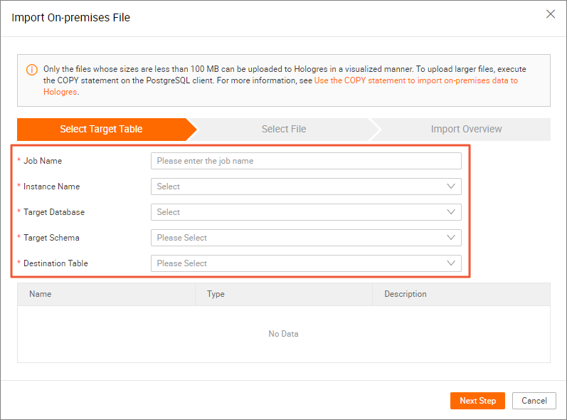
Specify the Hologres table to which you want to import data.
In the Import On-premises File dialog box, enter a job name, select the instance, database, and target table (accommodations or zipcode), and then click Next.
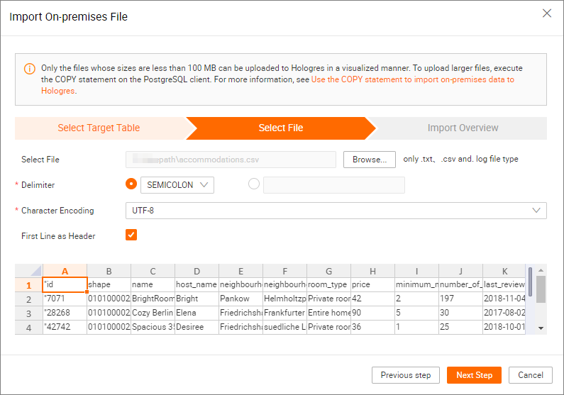
Specify the data that you need to import and the encoding format.
On the Upload File tab, configure the parameters as described in the following table and click Next.
Parameter
Description
Select File
Click Browse to upload the data file that you want to import. Only files with the .txt, .csv, or .log extension are supported. Select the accommodations or zipcode data file that you downloaded.
Delimiter
The delimiter that is used to separate data entries. In this example, select SEMICOLON.
NoteYou can also select the option to the right of the drop-down list and specify a custom delimiter based on your business requirements.
Original Encoding
In this example, select UTF-8.
First Line as Header
By default, this option is not selected. If the first row of the data that you want to import is used as the header of the Hologres table, select this option.
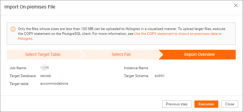
Confirm the configurations.
On the Import Overview tab, review the import details. If all information is correct, click Upload.
Verify the execution result.
After the job is complete, the system shows whether the execution is successful in the Import Overview step. If the execution fails, you can view the error cause for troubleshooting and import the data again.
You can also execute SQL statements in the SQL editor to query the number of data entries or detailed data in the destination Hologres table:
Check the number of data entries
The accommodations table should contain 22,248 records, and the zipcode table should contain 190 records.
SELECT COUNT(*) FROM accommodations; -- Query the number of records in the accommodations table.
SELECT COUNT(*) FROM zipcode; -- Query the number of records in the zipcode table.
Query the detailed data
SELECT * FROM accommodations; -- Query the records in the accommodations table.
SELECT * FROM zipcode; -- Query the records in the zipcode table.
Step 3: Use spatial functions to query data
After the required Hologres tables are created and the sample spatial data is imported to the tables, you can use spatial functions to query the spatial data in Hologres. The following examples are for your reference. For information about the syntax of spatial functions, see PostGIS for geographic information analysis.
Query the number of records in the accommodations table where the Spatial Reference Identifier (SRID) is 4326.
Sample code:
SELECT COUNT(*) FROM public.accommodations WHERE ST_SRID(shape) = 4326;Returned result:
 count
-------
 22248
(1 row)
Use the well-known text (WKT) format to query geometry objects that meet the specified conditions. In this example, you can check whether the ZIP codes in the zipcodes Hologres table are stored in World Geodetic System 1984 (WGS84). The system uses an SRID of 4326.
NoteOnly the spatial data entries that are in the same spatial reference system can be referenced by each other.
Sample code:
SELECT  ogc_field
        ,spatial_name
        ,spatial_type
        ,ST_SRID(wkb_geometry)
        ,ST_AsText(wkb_geometry)
FROM    public.zipcode
ORDER BY spatial_name
;
Returned result:
ogc_field  spatial_name  spatial_type  st_srid  st_astext
---------------------------------------------------------------
0           10115        Polygon        4326     POLYGON((...))
4           10117        Polygon        4326     POLYGON((...))
8           10119        Polygon        4326     POLYGON((...))
...
(190 rows returned)
Use the GeoJSON format to query the surface, the surface size, and the number of points on the surface for Mitte in Berlin with the SRID set to 10117.
Sample code:
SELECT  ogc_field
        ,spatial_name
        ,ST_AsGeoJSON(wkb_geometry)
        ,ST_Dimension(wkb_geometry)
        ,ST_NPoints(wkb_geometry)
FROM    public.zipcode
WHERE   spatial_name = '10117'
;
Returned result:
ogc_field  spatial_name  spatial_type                                   st_dimension  st_npoint
-----------------------------------------------------------------------------------------------
4           10117         {"type":"Polygon", "coordinates":[[[...]]]}    2             331
Query the number of accommodations within 500 meters of the Brandenburg Gate with the SRID set to 4326.
Sample code:
SELECT  COUNT(*)
FROM    public.accommodations
WHERE   ST_DistanceSphere(shape, ST_GeomFromText('POINT(13.377704 52.516431)', 4326)) < 500
;
Returned result:
 count
-------
    29
(1 row)
Perform a rough estimate of the location of the Brandenburg Gate based on the information about nearby accommodations.
Sample code:
WITH
    poi(loc) AS (
        SELECT st_astext(shape)
        FROM accommodations
        WHERE name LIKE '%brandenburg gate%' )
SELECT  COUNT(*)
FROM    accommodations a
        ,poi p
WHERE   ST_DistanceSphere(a.shape, ST_GeomFromText(p.loc, 4326)) < 500
;
Returned result:
 count
-------
    60
(1 row)
Query the detailed information about all the accommodations around the Brandenburg Gate and sort the accommodations in descending order by price.
Sample code:
SELECT  name
        ,price
        ,ST_AsText(shape)
FROM    public.accommodations
WHERE   ST_DistanceSphere(shape, ST_GeomFromText('POINT(13.377704 52.516431)', 4326)) < 500
ORDER BY price DESC
;
Returned result:
                        name                        | price |                st_astext
----------------------------------------------------+-------+------------------------------------------
 DUPLEX APARTMENT/PENTHOUSE in 5* LOCATION! 7583    |   300 | POINT(13.3826510209548 52.5159819722552)
 DUPLEX-PENTHOUSE IN FIRST LOCATION! 7582           |   300 | POINT(13.3799997083855 52.5135918444834)
 Luxury Apartment in Berlin Mitte with View         |   259 | POINT(13.3835653528534 52.516360156825)
 BIG APT 4 BLNCTY-CNTR 43-H6                        |   240 | POINT(13.3800222998777 52.5134224506894)
 BIG APARTMENT-PRIME LOCATION-BEST PRICE! B0303     |   240 | POINT(13.379745196599 52.5162648947249)
 BIG APARTMENT IN BRILLIANT LOCATION-CTY CENTRE B53 |   240 | POINT(13.381383105167 52.5157082721072)
 SONYCENTER: lux apartment - 3room/2bath. WIFI      |   235 | POINT(13.3743158954191 52.5125308432819)
 CENTRE APARTMENT FOR 6 | 8853                      |   220 | POINT(13.3819039478615 52.5134866767369)
 BIG APARTMENT FOR 6 - BEST LOCATION 8863           |   209 | POINT(13.3830430841658 52.5147824286783)
 3 ROOMS ONE AMAZING EXPERIENCE! 8762               |   190 | POINT(13.3819898503053 52.5144190764637)
 AAA LOCATION IN THE CENTRE H681                    |   170 | POINT(13.3821787206534 52.5129769242004)
 H672 Nice Apartment in CENTRAL LOCATION!           |   170 | POINT(13.3803137710339 52.5132386929089)
 "Best View -best location!"                        |   170 | POINT(13.3799551247135 52.5147888483851)
 H652 Best Location for 4!                          |   170 | POINT(13.3805705422409 52.5143845784482)
 H651 FIT´s for Four in a 5* Location!              |   150 | POINT(13.3822063502184 52.5134994650996)
 NEXT TO ATTRACTIONS! H252                          |   110 | POINT(13.3823616629115 52.5136258446666)
 CTY Centre Students Home| G4                       |   101 | POINT(13.3808081476226 52.5130957830586)
 Room for two with private shower / WC              |    99 | POINT(13.3786877948382 52.5208018292043)
 StudentsHome CityCentre Mitte 91-0703              |    95 | POINT(13.3810390515141 52.5142363781923)
 FIRST LOCATION - FAIR PRICE K621                   |    80 | POINT(13.3823909855061 52.5131554670458)
 LONG STAY FOR EXPATS/STUDENTS- CITY CENTRE | K921  |    75 | POINT(13.380320945399 52.512364557598)
 Nice4Students! City Centre 8732                    |    68 | POINT(13.3810147526683 52.5136623602882)
 Comfy Room in the heart of Berlin                  |    59 | POINT(13.3813167311819 52.5127345388756)
 FO(U)R STUDENTS HOME-Best centre Location!         |    57 | POINT(13.380850032042 52.5131726958513)
 Berlin Center Brandenburg Gate !!!                 |    55 | POINT(13.3849641540689 52.5163902851474)
 !!! BERLIN CENTER BRANDENBURG GATE                 |    55 | POINT(13.379997730927 52.5127577639174)
 Superb Double Bedroom in Central Berlin            |    52 | POINT(13.3792991992688 52.5156572293422)
 OMG! That’s so Berlin!                            |    49 | POINT(13.3754883007165 52.5153487677272)
 Apartment in Berlin's old city center              |    49 | POINT(13.3821761577766 52.514037240604)
(29 rows)
Query the detailed information about the accommodation with the highest price and its ZIP code.
Sample code:
SELECT  a.price
        ,a.name
        ,ST_AsText(a.shape)
        ,z.spatial_name
        ,ST_AsText(z.wkb_geometry)
FROM    accommodations a
        ,zipcode z
WHERE   price = 9000
AND     ST_Within(a.shape, z.wkb_geometry)
;
Returned result:
price   name                                 st_astext                                  spatial_name      st_astext
-------------------------------------------------------------------------------------------------------------------------------------------------
9000    Ueber den Dächern Berlins Zentrum    POINT(13.334436985013 52.4979779501538)    10777             POLYGON((13.3318284987227 52.4956021172799,...
Query the popular accommodations in Berlin, group the accommodations by ZIP code, and then sort the groups by the order volume.
Sample code:
SELECT  z.spatial_name AS zip
        ,COUNT(*) AS numAccommodations
FROM    public.accommodations a
        ,public.zipcode z
WHERE   ST_Within(a.shape, z.wkb_geometry)
GROUP BY zip
ORDER BY numAccommodations DESC
;
Returned result:
zip      numaccommodations
----------------------------
10245    872
10247    832
10437    733
10115    664
...
(187 rows returned)